Many aurora companies all over Scandinavia often say they have the clearest skies, they are in the driest location and that they offer the best chances of seeing the northern lights etc. But they can’t all be right can they? So who is right and who is wrong? We attempt to look at what areas suffer the most precipitation and what areas have very little.
The following images show the temperatures and precipitation from meteorological stations near some popular northern lights locations. Precipitation isn’t an exact guide for cloudiness of an area, but considering precipitation comes from clouds, we can certainly use it as a good guideline.
We are not saying a particular area is better than an other area. Neither are we saying we are better than any of them. We are merely presenting this data for you to see for yourself and come to your own conclusions.
Graphs and Data
Key
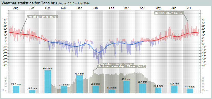
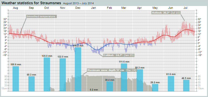
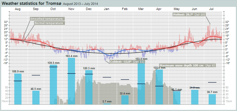
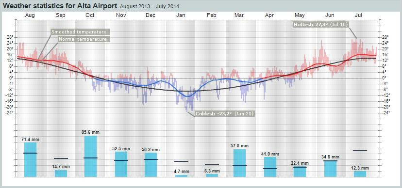
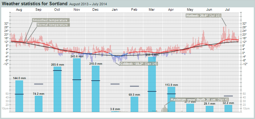
The light blue bars shows total precipitation for the month. The black lines crossing is the normal (mean) value for precipitation.
The red/blue line shows average temperature during the day (24h) (equalized for 30 days). The line is red by plus degrees, and blue by minus degrees.
The red/blue areas shows the temperature variations throughout the day (24h) with max- and min. temperature as endpoints. The area is red by plus degrees, and blue by minus degrees.
The dark grey bars behind the precipitation bars shows snow depth measured day by day.
Aurora Service Tours (mainly around Tana, Norway)
Although we are located between the towns of Utsjoki and Nuorgam in Finland, which are both on the Finnish side of the Norwegian border, Tana bru is a small town just inside of Norway where we mostly chase the lights. It is also where the husky adventures are located (if you choose that option).
Abisko, Sweden
(Straumsnes weather station is the closest official weather station, 44 km/27 miles away from Abisko National Park. Straumsnes is further inland from Narvik, closer to the Swedish border.)
Tromsø, Norway
Alta, Norway
Lofoten islands, Norway
(Sortland, is just slightly to the north of the Lofoten islands, but is still in the archipelago that Lofoten is a part of).
Conclusion
As you can see clearly, the precipitation for our area (in the first image) is considerably less than the other locations, and drier than some locations by an incredible margin.
When I was originally doing research on locations where to base our northern lights tours, I was actually quite surprised by some of the data I was uncovering. So not only are we in the highest geomagnetically active area of Lapland, it also appears we are in the driest.
Of course the above graphs are only based on last years weather. Weather is pretty variable, and can change one year from the next. So we can’t be certain if next year will have a similar pattern to the graphs above. But with climate change a real factor, who knows if the above graphs will be a permanent pattern (or get even worse for the coastal areas).
Thanks to Norwegian Meteorological Institute (www.yr.no) for the graphs & data.


 The dedicated northern lights holiday in Finland was conceived by us. We are the original!